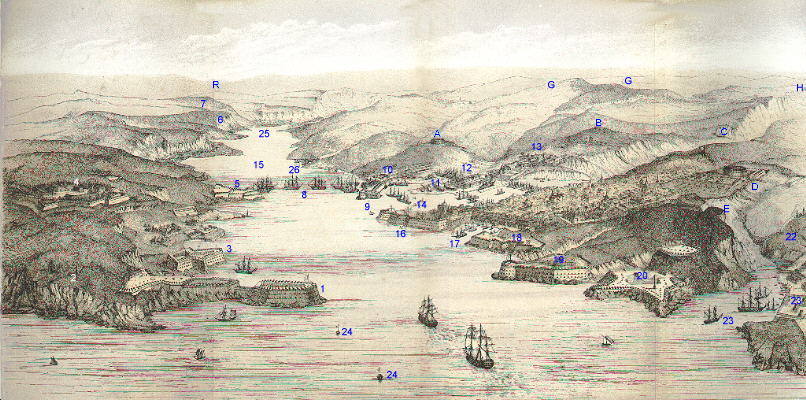
Sebastopol from the Sea
From The Invasion of the Crimea, Alexander William Kinglake, 1868


|
A. The Malakoff. B. The Redan. C. The Flagstaff Bastion. D. The Central Bastion. E. The (land) Quarantine Bastion. |
G.G. The English Camp. H. The Right of the French Camp. R. The spot from which Lord Raglan reconnoitred Sebastopol on the 25th Septr.
|
|
1. Fort Constantine & adjoining Batteries. 2. Telegraph Battery. 3. Fort Michael. 4. The Severnaya or Star Fort. 5. Batteries called Number Four. 6. West Lighthouse. 7. East Lighthouse. 8. Russian Ships. 9. Fort St Paul. 10. the Karabel Faubourg. 11. Basins and Docks. 12. Hospital. |
13. Prisons. 14. Man of War Harbour. 15. Roadstead. 16&17. Fort St Nicholas. 18. Artillery Fort. 19. Fort Alexander. 20. Quarantine Sea Fort. 22. Cemetery. 23. Port and Buildings of the Quarantine. 24. Buoys shewing the Reefs. 25. River Tchernaya. 26. Careenage Port. |
The line of sunken Ships (which does not appear in the drawing) stretched across the entrance of the Roadstead from the Reef beneath Fort Constantine to the one beneath Fort Alexander. The Chains stretched from the Reef beneath Fort Michael to the one beneath Fort Nicholas.
|
Back to Timeline |
|
Home |